Thank you for supporting this site ❤️
Make a donation
Make a donation
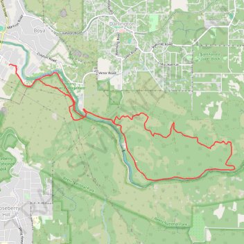
Perth - WAMC King of the Mountain
- Distance: 16.0 Km
- Elevation gain: 404 m
- Maximum elevation: 247 m
- Elevation loss: 401 m
- Minimum elevation: 22 m
- Moving time: 1 h 44 m
- Moving speed: 9.2 Km/h
- Maximum speed: 14.7 Km/h
- Total time: 1 h 44 m
- Global speed: 9.2 Km/h
Interactive trail map
Thank you for supporting this site ❤️
Make a donation
Make a donation
Trail profile
- Distance: 16.0 Km
- Elevation gain: 404 m
- Maximum elevation: 247 m
- Elevation loss: 401 m
- Minimum elevation: 22 m
- Moving time: 1 h 44 m
- Moving speed: 9.2 Km/h
- Maximum speed: 14.7 Km/h
- Total time: 1 h 44 m
- Global speed: 9.2 Km/h
Thank you for supporting this site ❤️
Make a donation
Make a donation
About this trail
Name: Perth - WAMC King of the Mountain trail, distance, elevation, map, profile, GPS track
Start: Helena Valley Road, Helena Valley, Western Australia, 6076, Australia (-31.92507 116.05036)
End: Helena Valley Road, Helena Valley, Western Australia, 6076, Australia (-31.92515 116.04954)
Coordinates: -31.94808 116.04954 -31.92485 116.10260
Thank you for supporting this site ❤️
Make a donation
Make a donation
Other hiking, mountain biking, running and outdoor activity trails
Click on a trail to view its statistics, map and profile.
Nyaania Creek Loop Walk Trail
Distance: 2.4 Km • Elevation gain: 106 m • Maximum elevation: 134 m
2021 Toodyay return via Kep
Distance: 229.9 Km • Elevation gain: 1,859 m • Maximum elevation: 357 m