Thank you for supporting this site ❤️
Make a donation
Make a donation
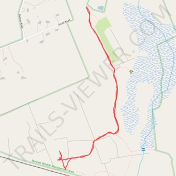
BWMA-04-24 19:17:30
- Distance: 3.0 Km
- Elevation gain: 49 m
- Maximum elevation: 268 m
- Elevation loss: 49 m
- Minimum elevation: 246 m
- Moving time: 50 m 47 s
- Moving speed: 3.6 Km/h
- Maximum speed: 8.6 Km/h
- Total time: 54 m 9 s
- Global speed: 3.4 Km/h
Interactive trail map
Thank you for supporting this site ❤️
Make a donation
Make a donation
Trail profile
- Distance: 3.0 Km
- Elevation gain: 49 m
- Maximum elevation: 268 m
- Elevation loss: 49 m
- Minimum elevation: 246 m
- Moving time: 50 m 47 s
- Moving speed: 3.6 Km/h
- Maximum speed: 8.6 Km/h
- Total time: 54 m 9 s
- Global speed: 3.4 Km/h
Thank you for supporting this site ❤️
Make a donation
Make a donation
About this trail
Name: BWMA-04-24 19:17:30 trail, distance, elevation, map, profile, GPS track
Start: Gould Road, Charlton, Worcester County, Massachusetts, 01542, United States (42.18718 -71.94405)
End: Gould Road, Charlton, Worcester County, Massachusetts, 01542, United States (42.18714 -71.94402)
Coordinates: 42.17742 -71.94638 42.18718 -71.94146
Thank you for supporting this site ❤️
Make a donation
Make a donation
Other hiking, mountain biking, running and outdoor activity trails
Click on a trail to view its statistics, map and profile.
BWMA-04-20 13:39:55
United States > Massachusetts > Worcester County > Charlton
Distance: 1.4 Km • Elevation gain: 23 m • Maximum elevation: 268 m