Thank you for supporting this site ❤️
Make a donation
Make a donation
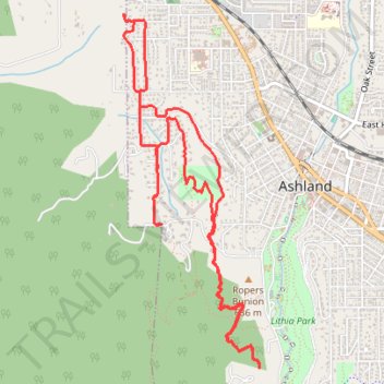
Jackson County - Steady State Run: 2 X 20 min w/
- Distance: 9.8 Km
- Elevation gain: 381 m
- Maximum elevation: 743 m
- Elevation loss: 380 m
- Minimum elevation: 629 m
- Moving time: 1 h 16 m
- Moving speed: 7.7 Km/h
- Maximum speed: 11.7 Km/h
- Total time: 1 h 16 m
- Global speed: 7.7 Km/h
Interactive trail map
Thank you for supporting this site ❤️
Make a donation
Make a donation
Trail profile
- Distance: 9.8 Km
- Elevation gain: 381 m
- Maximum elevation: 743 m
- Elevation loss: 380 m
- Minimum elevation: 629 m
- Moving time: 1 h 16 m
- Moving speed: 7.7 Km/h
- Maximum speed: 11.7 Km/h
- Total time: 1 h 16 m
- Global speed: 7.7 Km/h
Thank you for supporting this site ❤️
Make a donation
Make a donation
About this trail
Name: Jackson County - Steady State Run: 2 X 20 min w/ trail, distance, elevation, map, profile, GPS track
Coordinates: 42.18493 -122.73177 42.20872 -122.71948
Thank you for supporting this site ❤️
Make a donation
Make a donation
Other hiking, mountain biking, running and outdoor activity trails
Click on a trail to view its statistics, map and profile.
Jackson County - 0:45 Endurance Run w/ 4-6 Stride
United States > Oregon > Jackson County > Ashland
Distance: 6.0 Km • Elevation gain: 212 m • Maximum elevation: 743 m