Thank you for supporting this site ❤️
Make a donation
Make a donation
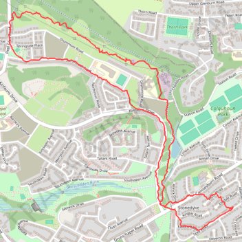
2026-06-10_15-55_Wed
- Distance: 5.4 Km
- Elevation gain: 73 m
- Maximum elevation: 51 m
- Elevation loss: 72 m
- Minimum elevation: 27 m
- Moving time: 1 h 20 m
- Moving speed: 4.1 Km/h
- Maximum speed: 8.5 Km/h
- Total time: 1 h 24 m
- Global speed: 3.8 Km/h
Interactive trail map
Thank you for supporting this site ❤️
Make a donation
Make a donation
Trail profile
- Distance: 5.4 Km
- Elevation gain: 73 m
- Maximum elevation: 51 m
- Elevation loss: 72 m
- Minimum elevation: 27 m
- Moving time: 1 h 20 m
- Moving speed: 4.1 Km/h
- Maximum speed: 8.5 Km/h
- Total time: 1 h 24 m
- Global speed: 3.8 Km/h
Thank you for supporting this site ❤️
Make a donation
Make a donation
About this trail
Name: 2026-06-10_15-55_Wed trail, distance, elevation, map, profile, GPS track
Coordinates: 55.90742 -4.36482 55.91966 -4.34246
Thank you for supporting this site ❤️
Make a donation
Make a donation
Other hiking, mountain biking, running and outdoor activity trails
Click on a trail to view its statistics, map and profile.
Tracked with OSMTracker for Android™
United Kingdom > Scotland > Glasgow City > Glasgow
Distance: 3.7 Km • Elevation gain: 46 m • Maximum elevation: 49 m
2026-06-10_15-55_Wed
United Kingdom > Scotland > East Dunbartonshire > Glasgow
Distance: 5.0 Km • Elevation gain: 58 m • Maximum elevation: 49 m